Hall Brook Headwaters
955 Hall Road : Lunenburg, VT 05906
Essex County, Vermont
Ranch Description
Property Overview
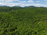
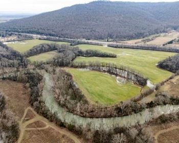
Located in rural Lunenburg, Vermont, this property offers the perfect blend of access to local amenities with the seclusion of Northeast Kingdom forestlands. The surrounding landscape is one of vast, undeveloped timberlands, mixed with well-maintained camps off Hall Road, which also serves as an ATV and snowmobile trail. Property highlights include:
-Standing timber value of $140,500, with a promising timber asset appreciation outlook
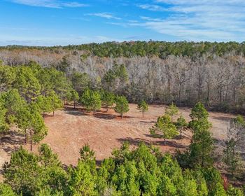
-Attractive forest conditions, with minimal low shrubs and regeneration creating easy walking conditions
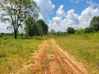
-Developed access off Hall Road, with a built driveway (right-of-way) accessing potential camp sites
-Mostly gentle terrain with trails ready to be upgraded
Location
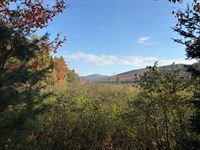
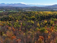
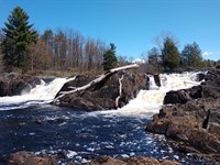
The forest is located in the town of Lunenburg, in the Northeast Kingdom, which borders New Hampshire and the Connecticut River. Much of the area is rural and characterized by a heavily forested landscape, with homes generally scattered, except for clusters found in small hamlets and along Neal Pond. Small farms along the Connecticut River are also prominent, contributing to the region's traditional working-land character. The landscape to the north is almost entirely forested and includes several larger timberland blocks under both private and public ownership. Neal Pond is a short distance to the south and features a public launch for fishing and boating. Lunenburg Village lies just 5.5 miles from the property via Route 2. The village offers a convenience store, post office, elementary school, and town municipal offices. The drive to the village along Pond Road passes occasional year-round homes, while the immediate Hall Road area is known for its numerous seasonal camps.
Lancaster, New Hampshire, is the closest major town, located about 10 miles east along the Connecticut and Israel Rivers. Lancaster serves as a regional hub with a vibrant downtown, offering full amenities and earning the reputation of the “Gateway to the Great North Woods.” The town can be found bordering the scenic, rolling mountains of the Kilkenny Range within the White Mountain National Forest. For broader regional access, Boston and Portland, Maine, are approximately a 2.5-Hour drive to the south and southeast. There are sites available for potential camp-building near the existing cleared log landing or at several other locations throughout the forest.
Access
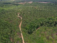
The property can be accessed via Hall Road, which is a Class 4 town road. This is followed by a legally deeded 50-foot-wide right-of-way (Row) that provides direct access to the property, stretching approximately 1,100 feet.
Although Hall Road is not maintained by the town and is not plowed during the winter months, nearby camp owners routinely maintain the road, ensuring it remains passable. During the winter, Hall Road serves as a significant Vast snowmobile trail.
Property Description
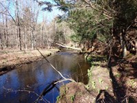
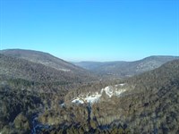
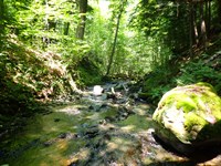
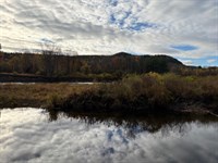
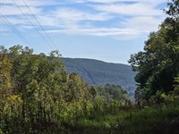
The land is primarily characterized by gentle slopes, with some steeper sections forming a hillside that faces southwest. The elevation ranges from approximately 1,620 feet above sea level (Asl) in the east, where a log landing and potential campsite locations are found, to about 1,940 feet ASL at the height of land to the north. A small stream drains this hillside, flowing southwest and eventually forming Hall Brook, which empties into the Connecticut River to the west.
The ground conditions and slopes are favorable for timber harvesting and recreational activities, with very little difficult terrain limiting access. Some areas of the property are upland and quite dry, while other regions to the west contain more softwood timber and riparian zones, providing excellent wildlife habitat.
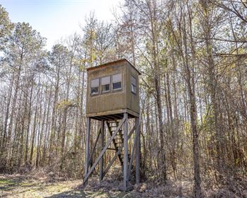
Forest trails, created from previous logging activities, can be found throughout the property, offering access for off-trail snowmobiling, ATV riding, hunting, and hiking. Hall Road itself serves as a Vast Snowmobile Trail during the winter months, providing access to major trails leading to points of interest in Vermont and New Hampshire. There are several potential camping sites available near the existing cleared log landing and at various points throughout the forest.
Timber Resource
Timber data in this report is based on a comprehensive timber inventory completed in June of 2023 to establish Capital Timber Value (Ctv), then grown forward two growing seasons using current FIA growth data. Thirty-six inventory points (1 plot per 3.6 forested acres) were sampled, covering a 415' x 415' grid using a 15-factor prism. Sampling statistics are ±30% standard error for sawlog products and ±13.7% for all products combined at the 95% confidence interval.
The timber data revealed a total sawlog volume of 481 MBF International ¼” scale (3.7 Mbf/Acre), with 2,751 pulpwood cords (21 cords/acre). The combined total commercial per-acre volume is 28.4 cords, a figure above average for the region. Stumpage values were assigned to the volumes in August 2025, producing a property-wide Capital Timber Value (Ctv) of $140,500 ($1,072/Acre). See the Timber Valuation in this report for details.
Species Composition
Hardwoods dominate the species composition, accounting for 89% of the total volume, while softwoods make up 12%. The overall mix closely mirrors that of the surrounding region, with sugar maple comprising 47% of the total volume, followed by red spruce (32%), white ash (8%), yellow birch (6%), black cherry (3%), and miscellaneous hardwoods.
The sawlog volume breakdown reflects strong market demand, led by sugar maple, yellow birch, white ash, spruce/fir, white birch, aspen, and black cherry. A notable attribute is the limited presence of beech in both the overstory and understory.
Sawlog Value
Sawlog value is concentrated in sugar maple (53%), red spruce (28%), white ash (11%), and yellow birch (4%), with the balance in miscellaneous species.
Diameter Distribution
The average diameter for all products combined is 11.1 inches, while sawlogs average 11.7 inches. Sugar maple, the dominant species, averages 13.0 inches. Overall, the forest consists of two primary age classes: an older cohort, roughly 70 years old and scattered throughout the property, and a younger cohort established about 35 years ago following a heavy harvest.
Stocking & Stem Quality
Fully stocked stands represent forest density. The average basal area (Ba) is around 97 ft² on 296 stems per acre. Stem quality is well above average for the region, with acceptable growing stock BA at 81 ft². The younger age class is high in density, with straight, clean, and tall stems perfectly positioned for future asset appreciation and for shifting products to higher-value sawlogs and veneer. The older age class represents a strong income opportunity the next time the property is silviculturally treated.
Ranch Maps & Attachments
Directions to Ranch
From Lunenburg Village, head north 0.4 miles on Bobbin Hill/Pond Hill Road. Bear left to continue on Pond Hill Road and proceed for 2.9 miles. Turn right onto Hall Road and follow it for 1.8 miles to reach the property.
More Ranch Details
More Ranches from Thom Milke
 582 AC : $1.92M
- 87.7 AC : $203K
- 54 AC : $850K
- 238.1 AC : $595K
- 515 AC : $705K
- 91.1 AC : $462K
- 256 AC : $920K
- 1,184 AC : $2.87M
- 88.5 AC : $359K
- 12 AC : $59.9K
- 14 AC : $100K
- 80 AC : $154K