Marshall Phillips Forest
Marshall Phillips Road : Brandon, VT 05733
Rutland County, Vermont
Ranch Description
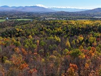
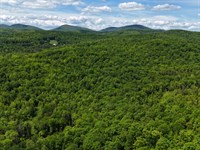
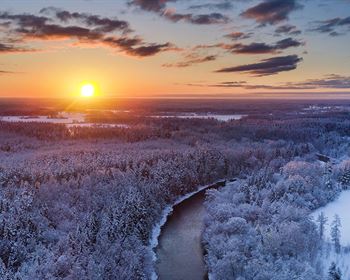
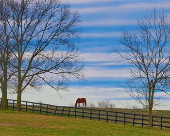
Marshall Phillips Forest is found in the southern end of the Champlain Valley in west-central Vermont. A wide valley between the Green Mountain Range to the east and sprawling Lake Champlain to the west. The lower elevations of this parcel offer a flatter landscape, making hiking through this property less strenuous than the usual steeper terrain of Vermont hillsides. The forest ecosystem on this parcel would support a different mix of plant and animal species than are seen in the predominantly mountainous terrain in the rest of the state. Rivers, brooks and ponds are found nearby, and boating, fishing, and biking are available close to this parcel.
This property sits partially in the towns of Brandon and Sudbury. Brandon is the closest town with several good restaurants, a brewery, and a main street dotted with local shops and a vibrant arts community. Sudbury is a smaller community with a village center to the east. Middlebury is a larger town and is home to the famed Middlebury College, only 17 miles north of Brandon. US Route 7 runs north-south through the Champlain Valley, connecting Brandon with Middlebury and Burlington (50 miles) to the north and Rutland and the east-west US Route 4 to the south. Boston is 3.5 hours to the southeast, while New York City is 5 hours to the south.
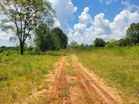
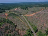
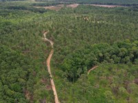
The property offers almost 1,800' of frontage on Marshall Phillips Road in Brandon, a town-maintained gravel road with utilities known as Town Highway 15. At this road frontage, a 60' wide, gated driveway provides access to the western end of the property. This grass driveway has been well maintained over the years and leads 1,500' into the property's northern end, where an open clearing is found. At the eastern end of the frontage along the boundary, an established driveway leads a short distance into the property before becoming a woods trail heading around the wetland and into the southern reaches of the property.
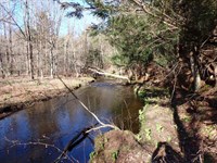
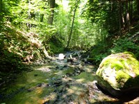
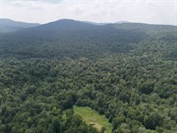
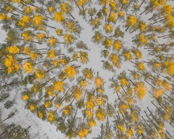
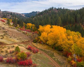
Marshall Phillips Forest offers a variety of terrain and habitats suitable for residential development, with hiking, nature viewing, and hunting all found within its 256 acres. Most of the forest showcases different tree species, and the value is detailed in the timber section below. There are sections of wetlands in the forest associated with small brooks that flow through the property. These wetland areas have different characteristics, from marsh grass areas to ponds and streams, and forested areas with cedar trees. This rich ecosystem would host a wide variety of bird and animal life for viewing. There would be a myriad of songbirds, waterfowl, and marsh-dwelling birds, with the occasional Bald Eagle found in this area. The forest ecosystem would attract bears, foxes, and coyotes, along with numerous deer, due to the natural food sources of hemlock, oak, small saplings, and edible ground cover. You might even spot an odd apple tree in the forest, as there is evidence of an old farmstead with stone walls and trails found within the forest's interior.
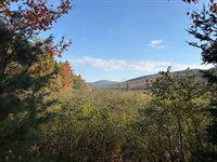
On the property's western edge at the end of the driveway is an elevated peninsula that has been cleared and maintained, leaving a large open grass-covered clearing perfect for a home or camp. The remaining open area provides a gentle slope towards the wetland with scenic views and towards the property's hardwood slopes to the south. There are good views of local mountains from the potential house site, and additional tree clearing to the east would open views of the wetland area and local mountains.
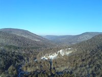
Accessing the property from the driveway at the eastern end of the road frontage takes you to a wide, flat knoll populated by a middle-aged mixed wood forest. This private site offers a second good option for a camp or year-round home development, as power runs along Marshall Phillips Road. This access point is above the wetland area and provides good walking to the largest part of the forested landscape. As you move along old woods trails, the forest transitions to more mature stands on gentle terrain. On the property's eastern edge, one can access a highly scenic area known as “The Ledges.” Near these ledges is a fringe of wetland, with a towering stand of hemlocks that slopes steeply upward toward rocky outcrops. Walking under the canopy of towering trees with exposed rock faces looming above creates a surrealistic atmosphere that could be found in a primeval forest.
Above The Ledges is a mature mixed wood stand, and west of here, at the land's southern slopes, there is an attractive hardwood stand of oak, maple, and hickory. The highest elevation on this parcel is roughly 840' above sea level along the southern boundary, and the lowest elevation is found in the wetland area at around 480'.
The seller acquired the property in late 2017; since then, no timber harvesting has occurred. Their forest management activities over this period included preparing a forest management plan for 2019 (copy available upon request), annual mowing of the access road, and eradicating invasive species on the east side of the wetlands under the Nrcs cost-share program.
Using the management plan timber inventory data, the total sawlog volume is estimated to be 2,154 MBF International ¼” scale (9.9 Mbf/Commercial acre), with 3,778 pulpwood cords (17.4 cords/commercial acre). The combined total commercial per-acre volume is 37.4 cords, which is above the average for the region. Stumpage values were assigned to the volumes in June of 2025, producing a rough property-wide Capital Timber Value (Ctv) of $293,000 ($1,350/Commercial acre). See the Rough Timber Volume & Values table in this report for details.
The species composition is 68% softwoods and 32% hardwoods. The combined species composition for all products is led by white pine (43%), hemlock (19%), and other miscellaneous species, as shown in the graphic below. East of the wetlands are areas of white pine and Norway spruce plantations established around 1950.
Forest density is represented by fully stocked stands with an average Basal Area (Ba) of 97 ft2. The average sawlog diameter (by volume) is 16.5”, with the average diameter for all products combined 14.4”. Harvesting last occurred on the west side of the wetlands in 2016, where group patch cuts occurred in the pine stands. The remainder of the forest was last thinned +/-25 years ago. Wetlands, including some interesting, forested wetlands, cover +/-75 acres.
Ranch Maps & Attachments
Directions to Ranch
From Brandon VT Head west on Conant Square toward Briggs Ln 0.2 mi. Turn left onto Pearl St 1.7 mi. Turn left onto Short Swamp Rd 1.0 mi. Turn right onto Marshall Phillips Rd 0.4 mi. Marshall Phillips Rd.
More Ranch Details
More Ranches from Thom Milke
 582 AC : $1.92M
- 87.7 AC : $203K
- 54 AC : $850K
- 238.1 AC : $595K
- 515 AC : $705K
- 91.1 AC : $462K
- 88.5 AC : $359K
- 270 AC : $800K
- 256 AC : $920K
- 241 AC : $3.3M
- 1,184 AC : $2.87M
- 261 AC : $428K