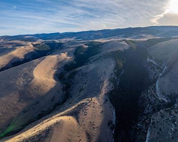
76 Acre Mountain Top Lot
Foresthill, CA 95631
Placer County, California
Ranch Description
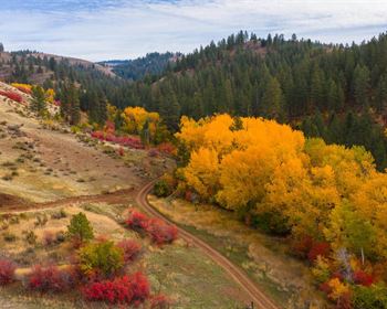
Off-Grid Living. Build Your Dream Cabin OR A Private Retreat Center. Picturesque mountain lot, backing to US Government owned land all the way to Lake Tahoe. Wildlife viewing, hunting, and extensive trail systems for hiking. ATV in summer and snowmobile or cross-country ski in the winter. Stunning views and space to build a private retreat, use for agricultural/farming/growing, or build a campground or vacation rentals. Nearby French Meadows Reservoir and short hike to Duncan Peak. Top of lot has a beautiful granite rock peak, flat area across the top then slopes down to another flat area in the middle and another near the bottom of lot. Running stream just off end of property. Seasonal stream on lot from snow runoff. Survey from County available in the images.
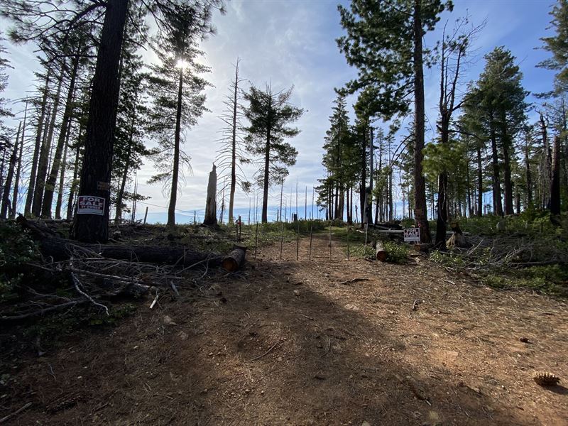
11.5 Gallons per minute well and 550 Gallon storage tank housed in a cinderblock structure. 1 additional water holding tanks at garden box area of property. Generator, Garden Boxes, Holding tanks, and drip lines included. Possible Harvest Plan with Sierra Pacific? Very Secluded Property.
Cash Price Is Options Include: with 145k down and and with 65k down and 2451.57/Month.
If these options don't work, let's talk and see if we can find a package that fits your budget.
Duncan Peak - 1.58 Miles
French Meadow Reservoir - 3.5 Miles
Donner Ski - 18 Miles
Lake Tahoe - 20 Miles
Land Data
Property Address: FORESTHILL, CA, 95631
County: Placer County
State: CA
Lot Number: n/a
Legal Description: 76.7 A FR SEC 21 15 13
Parcel Size: 76.7 acres
Approximate Dimensions: 1293.6 ft x 485.76 ft x 644.16 ft x 1483.68 ft x 1298.88 ft x 807.84 ft x 1488.96 ft Approx
GPS Center Coordinates (Approximate): 39.13300, -120.5371
Gps Corner Coordinates (Approximate):
39.1356, -120.5333
39.1321, -120.5333
39.1321, -120.5350
39.1303, -120.5350
39.1302, -120.5402
39.1338, -120.5402
Elevation: 6046.6 ft
Access to the property: Private Maintained Road
Road Surface Type: Unimproved
Road Frontage Type: Private Road, State Road
Is there a Structure? Yes. Commodity Shed; 550 Gallon storage tank housed in a cinderblock structure. 1 additional water holding tanks at garden box area of the property. Generator, Garden Boxes.
Closest major city: Auburn
How much is the annual property tax? for 2021
Zoning: RF 80 AC. Min. - Residential Forest (Rf) District - Agricultural/Residential/Recreation/Timber/Open Space Uses
Terrain type: Flat and Slope
Some areas are cleared at the top, middle and bottom of lot. Top of lot is flat across most of the lot, slopes up to the right to a beautiful rocky ridge.
Use for Residential, Agricultural, Resource and Open Space Uses.
Camping is allowed in this property.
11.5 Gallons per minute well with generator housed in a cinderblock structure. 1 additional water holding tanks at garden box area of the property. Generator, Garden Boxes, Holding tank.
Possible Harvest Plan with Sierra Pacific? Very Secluded Property.
Requires septic.
Does the property currently have electricity connected? No
What type of gas does this area service (Propane gas/Natural gas/ tank gas/etc)? None
Lot Access:
The property has 2 access points.
Cavanaugh Ridge Rd to Forest Service Rd 44. Take Foresthill Rd, turn right at Robinson Flat Campground.
EASIER Access: Mosquito Ridge to Deep Canyon Rd - the backside of the property. Request turn by turn directions with photos from me by email.
Can set up a site visit, or you can follow me up to the lot.
Utilities:
No utilities are available but there is a generator onsite and a certified 11+ gallons per minute producing well on the property that was dug roughly 285 feet down.
Mineral Rights:
Mineral rights will be included in the purchase.
Timbering Rights:
As part of the Zoning includes Forestry, you can harvest your own timber to build your dream home or cabin with or sell. You can even crate a logging camp and have your own sawmill.
Please contact me and I can email you directions with photos to get your there on your own, or we can schedule to meet and drive up together.