Barnard Ridge
Morgan Road : Barnard, VT 05031
Windsor County, Vermont

Ranch Description
Barnard Ridge Forest is ideally suited to the development of a private, year-round homestead with features that include:
20-minute walk to Barnard Village and Silver Lake, and 3-minute walk to the Barnard Inn restaurant;
Prime potential home site, including one at the top of the mountain with panoramic views;
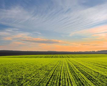
Aesthetic forest conditions with trails, large maturing sugar maple trees and ±5,000 potential maple taps.
The property is located just a 20-minute walk from the center of Barnard Village, a tiny but culturally diverse community located in central Vermont. At its heart is 84-acre Silver Lake which hosts seasonal and year-round shoreline homes, a town beach and a state park at its northern end. Across from the lake is the Barnard General Store, a popular stop featuring local prepared foods. The village is a popular destination in all four seasons, by both locals and tourists, with lodging available in the form of several bed and breakfast establishments. In particular, just at the junction of Bennett Road and Route 12 (3-minute walk from the land) is the Barnard Inn & Restaurant, a well known eating establishment.
Woodstock Village is 9 miles to the south, with the junction of I-89 and I-91 31 miles to the southeast. Boston is about a 2.5-Hour drive to the southeast.
Access is provided by 309' of frontage along a private, graveled road with electric and telephone service roadside. While no current driveway into the property is established along this road, the terrain does allow for development of a driveway to access a house site above the road. There is only one home along this road which is at the end of the road just beyond the property's frontage, thus the area has minimal road noise from traffic.
The land also benefits from 2,340' of frontage along Old Chateauguay Road (aka Morgan Road), a Class 4 road which is not town maintained. Currently, this road is not passable to cars, but has been used in the past for forest management purposes.
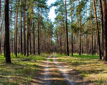
Internal access includes a comprehensive network of woods trails, one of which leads to the land's ridgeline peak.
One of the property's unique attributes is its level mountain ridge at an elevation of 1,920' ASL (above sea level). This site is buildable and would offer panoramic views with tree clearing. The property's internal woods trail network leads to this site, and the terrain leading to the peak will allow for development of a driveway with considerable earth work. The neighboring landowner has built a home on this same ridge due north of the property (see the aerial photograph in the map section to the right).
Alternatively, a home site is available just off the town road frontage, as this area offers gentle terrain where a large yard and clearing can be established. In this area, various well-built old stone walls are present that will enhance any landscaping on the developed home site.
The property's terrain is variable, with more gentle slopes near the road frontage and steeper slopes leading to the land's two peaks. Elevation ranges from 1,920' ASL on the ridgetop to 1,540' ASL along the road frontage. Aspects are generally easterly. Given that the property is situated at the top of the watershed (at the height of the land), there are no streams running through the property. Soils are well drained and highly productive.
The timber resource can be considered well above average, having been professionally managed by the current owner since her acquisition of the property in 1994.
The tree species composition is nearly pure sugar maple, with a cohort of white ash, hornbeam and beech. The forest management plan (available upon request) delineates two forest stands, each maturing sugar maple types.
Tree density is high and diameters are fairly large, creating minimal understory growth in many areas and facilitating easy walking conditions.
The forest was thinned in 1999 using individual tree selection. The results are impressive: adequate growing conditions have resulted in a forest where nearly all residual stems are of high quality, ensuring robust future growth and value appreciation.
For the hobby sugarbush operator, the land could likely sustain ±5,000 taps.